Copyright © Center for Environmental Visualization| ALL RIGHTS RESERVED.
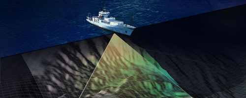
This illustration was done for an NSF Proposal for Mapping a portion of the Juan de Fuca Plate. The ship is the R/V Thompson, the Univeristy of Washington’s Research Vessel. The ship is equipped with an EM300 Sonar for swath mapping (represented in the figure).
CEV collaborated with John Delaney, School of Oceanography, University of Washington on this illustration. Seafloor bathymetry was visualized using IRIS Explorer, compositing and illustrating done with Photoshop.